Showing posts with label Hiking. Show all posts
Thursday, November 10, 2011
Hiking to the Boiling Lake on Dominica is by far one of the most amazing things I’ve ever done. The trail is about seven miles each way and took us seven hours to hike, we stopped a few times along the way. It was an all day hike and at one point I didn’t think I’d make it; the terrain was really challenging for me. We had the best guide on the island, Nahjie, who not only lives in Laudat (which makes the Boiling Lake in his ‘backyard’) but holds the record for hiking to the Boiling Lake in one day – Nahjie has hiked to the Boiling Lake three times in one day, AMAZING!!!


You can see the steam from the Boiling Lake in the distance, just a couple more mountains to climb...


The Valley of Desolation is surreal, it’s so alive with boiling volcanic activity, steaming, sulfur smells, a rainbow of mineral colors, and dangerous in places. Nahjie showed us a spot where the sulfur turned into a mud and makes an amazing facemask for cleaning the skin. So we did the rest of the hike in a sulfur mud mask.


We made it and ate lunch!!!


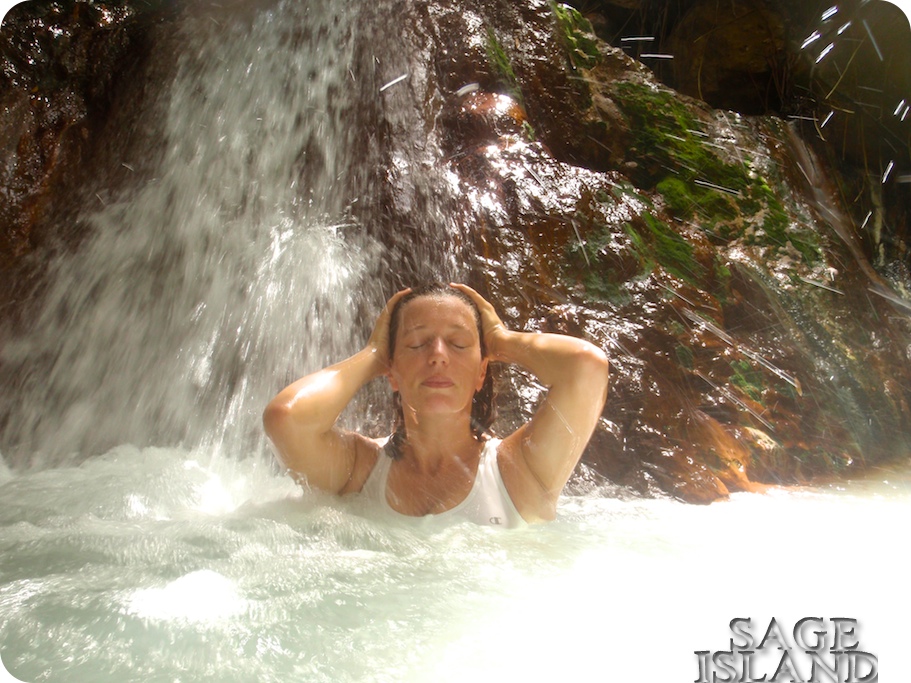
 A short distance after the Valley of Desolation there are three pools of hot water that we stopped to soak our fatigued muscles in. This was my favorite part of the hike, it was like bath water and extremely difficult to leave.


See the little village? The white specks to the left of the mountain. That's where we started and we're where almost, almost, half way done!


Vally of Desolation in action.


The Boiling Lake in action.


Thursday, September 29, 2011


Middleham Falls is one of the tallest waterfalls on Dominica. The trail entrance to Middleham Falls is in Laudat and has a well-marked sign that makes it easy to find. I recommend picking up a copy of Bradt’s Travel Guide of Dominica by Paul Crask, this is a fantastic guide with clear directions and tips.

The Middleham Falls hike takes about an hour each way, has a well-maintained path with steps and bridges, and is an enjoyable hike through the rainforest. I saw an Agouti (looks like a Guinea Pig) for the first time, some of the larges Chataignier Trees I’ve ever seen, and had a chance to break my FiveFinger hiking shoes in on this trail. I would highly recommend this experience to anyone visiting Dominica.


Monday, December 6, 2010
My walk today took me up to the old ruins of the Leinster Bay Estate House, built back in the 1700's for James Murphy. The ruins are off of the Johnny Horn Trail, which is connected to Leinster Bay Trail on the eastern end of the beach at Waterlemon bay. The ruins are located on top of a hillside and provide an amazing view of St. John; Annaberg, Mary Point, Water Bay, Leinster Bay, and Brown Bay. One can also see Fungi Passage, between Whistling Cay and Mary Point as well as Great Thatch, Little Thatch, and Tortola. The old estate has also been called Windy Hill and The Bad Boys Home.

You can see The Bad Boys Home Ruins up on top of the hill on the right.
 Take the second right at the bush :)

 A Red Tail Hawk

 Waterlemon Cay has amazing snorkeling.

 This is the view looking over Tortola, Little Thatch, and Drakes Passage.

This is a view of Leinster Bay, Waterlemon Cay, Mary Point, and Great Thatch Island.


For the best hiking information pick up a copy of Feet, Fins & Four - Wheel Drive by Pam Gaffin.

Links to additional information and where I gathered my facts:
http://www.stjohnbeachguide.com/Johnny%20Horn%20Trail.htm
http://www.seestjohn.com/trails_johnny_horn.html

Thanks for stopping by my blog!


Saturday, April 3, 2010
The Yawzi Point Trail on St. John is my favorite trail to photograph. The trail is a .3 mile long peninsula that divides Great and Little Lameshur Bays. It takes about 20 minutes to hike if you’re not me photographing, and has excellent snorkeling.

The history of the peninsula is really interesting. Near the beginning of the trail, about half way up the first hill there is the remains of two old stone ruins of a foundations. It is said that these are the remains of the Yawzi Quarantine Camp. This is where they would bring slaves that had contracted Yaws, a skin disease similar to Leprosy, to isolate them until they died.

The trail itself is usually overgrown, depending on the time of year that you visit and juts out into the ocean with a spectacular view. The reason that I am so drawn to this trail to photograph is the flora, it is amazing and always changing. It is located on the south side of St. John, which is hotter and more arid then the rest of the island. The trail winds and weaves through a lot of thorny vegetation, many different types of cactus like Turks Caps and Queen of the Night, century plants, maran bush, frangipani and many others.

Please take a look at the photos bellow.


The photo above and below are the exact same location on the trail, at two different times of year.


Related Posts Plugin for WordPress, Blogger...